Shelterbelts


This is an open-source Python package for mapping and categorising shelterbelts (windbreaks) across Australia using satellite imagery, in preparation for measuring their impacts on agricultural productivity at scale.
Key Features
Tree categorisation: classifies pixels as scattered trees, patch core, patch edge, or corridors based on nearby connectivity.
Cover categorisation: overlays ESA WorldCover 2021 land-cover classes (grassland, cropland, urban, water) onto the tree categories
Buffer categorisation: identify riparian and roadside tree buffers using the National Surface Hydrology Lines and National Roads datasets
Shelter categorisation: determine sheltered vs. unsheltered farmland based on tree density or wind direction, similar to Stewart et al. 2024
Patch & class metrics: compute patch and class landscape statistics similar to FragStats
Opportunities mapping: identify potential locations for additional tree plantings (currently a work-in-progress)
API integrations: download data from ANU BARRA-C2 (wind), WRI Canopy Height, and ESA WorldCover
Command-line interface: all index modules can be run in python scripts or directly from the terminal
Scalable: designed for national-scale processing on HPC systems (NCI Gadi)
Classifying trees from raw inputs: LAZ point clouds (via PDAL), Sentinel-2 imagery (with a bundled pre-trained neural network), or train your own model on labelled tiles
Example Output
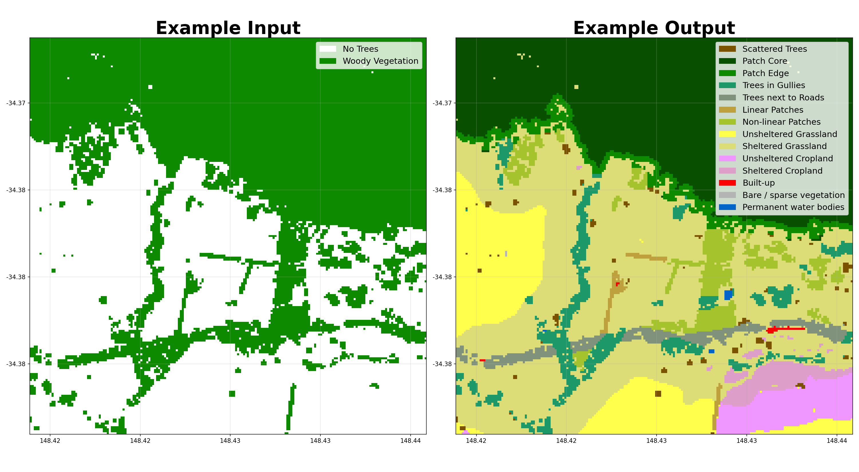
The plot below shows the full categorisation pipeline: a binary tree-cover raster on the left, and the final shelter categories on the right (sheltered grassland and cropland labelled by the type of tree providing the shelter).
Visualise Results
You can explore results interactively in the Google Earth Engine App.
Github Repository
You can find installation instructions on the README of the GitHub repository.
Parameter Reference
The main parameters for categorising shelterbelts are below. “Less” and “More” are preset bundles of these thresholds (e.g. the “less wind method” / “more wind method” layers in the Earth Engine app) that make the classifier detect fewer or more shelterbelts overall — they are not related to wind speed, despite the layer names.
Parameter |
Default |
Less |
More |
Description |
|---|---|---|---|---|
|
20 |
25 |
15 |
Minimum area (pixels) to classify as a patch rather than scattered trees |
|
1000 |
500 |
2000 |
Minimum patch size (pixels) to classify as a core area |
|
4 |
3 |
5 |
Distance (pixels) defining the edge region around patch cores |
|
4 |
3 |
5 |
Number of pixels away from a feature that still counts as within the buffer |
|
20 |
10 |
30 |
Distance from trees that counts as sheltered |
|
5 |
3 |
10 |
Percentage tree cover within |
|
20 |
25 |
15 |
Wind speed threshold in km/h |
|
WINDWARD |
MOST_COMMON |
WINDWARD |
Method to determine primary wind direction |
|
20 |
25 |
15 |
Minimum skeleton length (pixels) to classify a cluster as linear |
|
6 |
5 |
7 |
Maximum skeleton width (pixels) to classify a cluster as linear |